9:04:35
caption
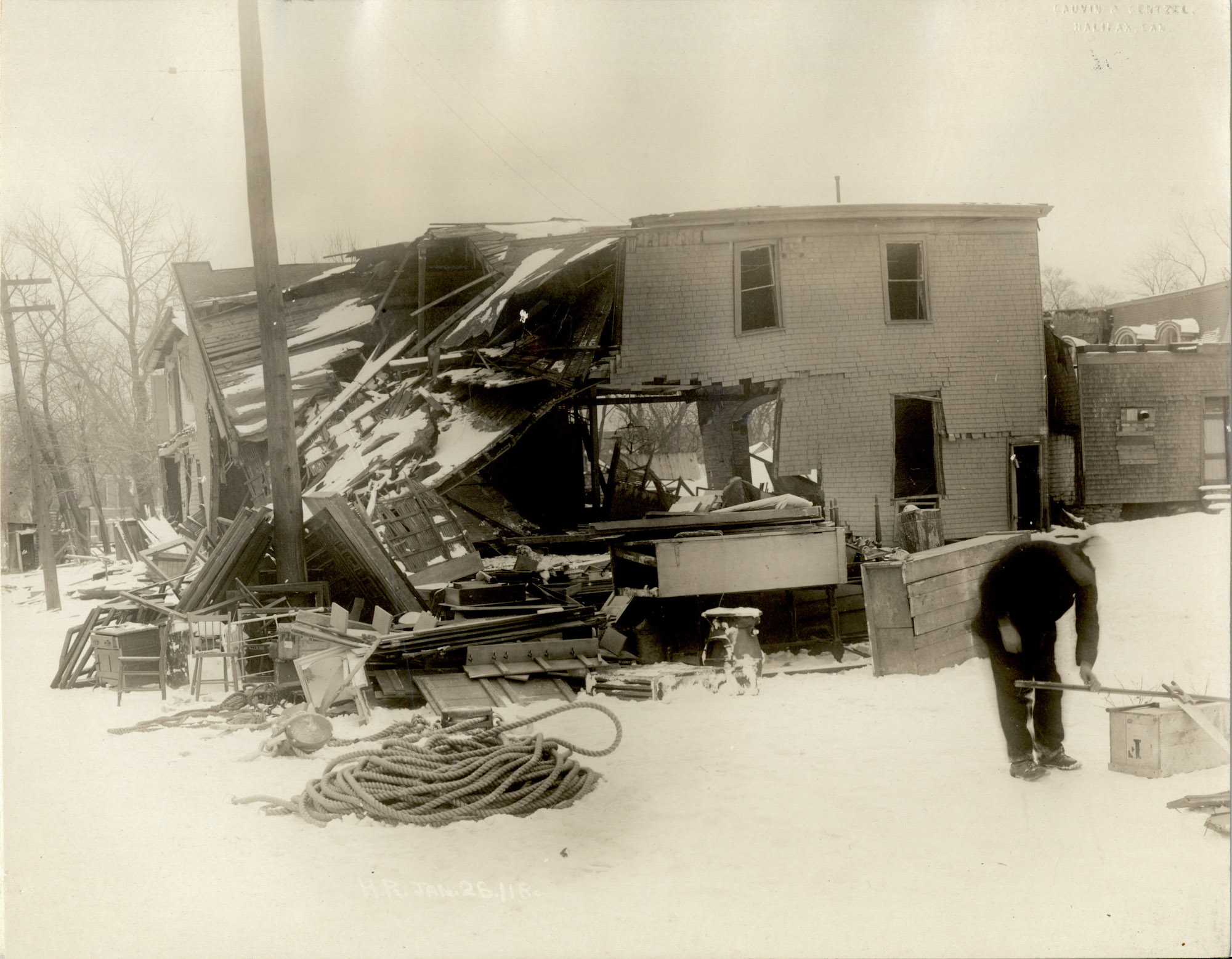
Halifax, N.S.: Damage caused by the explosion.A hundred years ago, on Dec. 6, 1917, at 9:04:35 in the morning, the deadly cargo of the French tramp steamer SS Mont-Blanc blew skyward in a monumental explosion that levelled a large part of North End Halifax and killed as many as 2,000, possibly more.
The Mont-Blanc’s forward cargo holds had been pierced about 20 minutes earlier by the SS IMO, a vessel headed for New York to pick up supplies for the Belgian relief effort. The collision happened when the two ships were both trying to navigate the Narrows, where the shorelines of Halifax and Dartmouth are closest together.
A raging fire that followed the collision, fed by barrels of volatile benzol tied on Mont-Blanc’s deck, burned for about 20 minutes as the doomed ship drifted toward Pier 6 on the Halifax side.
When the cargo of munitions went up, the blast wave from the explosion destroyed the entire Richmond neighbourhood perched on the steep slope on the Halifax side. Related stories
All over Richmond and adjacent areas, people were buried beneath the rubble of buildings, thrown to their deaths by the blast wave and washed away by a tsunami caused by the explosion. Buildings were damaged and glass shattered for kilometres around.
This package reported and edited by King’s journalism students combines data-driven and traditional reporting to produce stories that explore the heroic efforts in the immediate aftermath of the explosion, the lost Mi’kmaq community of Turtle Grove and the work of the Halifax Relief Commission to rebuild the devastated area. Students also photographed sites affected by the explosion as they exist today and created maps that provide an unprecedented, digital view of the disaster.
Mapping the devastation
The digital maps shown here allow for a deep exploration of the damage and the loss of human life on the Halifax side of the harbour. The information on the maps is derived from the holdings of the Nova Scotia Archives. See here for information on methods and sources.
On the first map below, buildings that existed in the devastated area are colour coded to show how badly damaged they were by the explosion.
The small green circles on the map represent the location of more than 1,000 properties inspected by the Halifax Relief Commission as part of the process of assessing damage claims.
The darker the colour of the circles, the greater the required repairs as a percentage of the original value of the building. Grey circles indicate buildings for which there was no original value or no repair cost indicated.
The map provides a never-before-published digital view of the damage field from the explosion, out to two kilometres from the epicentre. Click on the buildings and circles for more detailed information on each location, including its approximate distance from the explosion. Zooming closer will reveal rich detail, while the wide view shows the pattern of devastation.
(Access a legend by clicking on the arrows at the top of the map)
View larger map
Streets shown in black on the map above represent the street pattern of 1917. The underlying map shows today’s street pattern. Information on damage in Dartmouth could not be mapped because records kept for Dartmouth did not include street numbers.
Mapping loss of life
The human cost of the tragedy was incalculable.
People who had rushed down to the waterfront to watch the burning Mont-Blanc perished instantly; those watching through the windows of homes and other buildings were killed or blinded when windows exploded inward.
The remembrance book maintained online by the Nova Scotia Archives currently lists 1,835 known victims. Of those listed, fully half had addresses on just five streets: Barrington, Veith, Albert, Union and Duffus. Twenty-two per cent had addresses on Barrington Street.
The book of remembrance lists 612 victims known to have been 17 or under.
Those who died came from all over Halifax, as well as more than 60 from Dartmouth.
“The explosion affected everyone in the city,” said Glenn Taylor, who has been researching Halifax history as a hobby for years.
At the time of the explosion, 50,000 people lived in Halifax; which means more than 23 per cent of the residents were directly affected by the tragedy.
It’s the equivalent of 95,000 dead or injured in such a disaster today, based on the current population of Halifax.
“Everyone knew someone who was hurt, blinded or even killed in the explosion. Not only did they know someone, but they also saw the bodies on the streets and the houses burnt down,” said Taylor.
This map shows the addresses of those who died, lived in Halifax and for which street numbers are listed in the book of remembrance. Clicking each dot shows the number of those who died who lived at that address.
View larger map
Families around the world felt the stinging loss from the explosion, as people from 12 foreign countries died, most of them crew members on ships that were in the harbour at the time.
Almost half died on the SS Curaca, according to the Maritime Museum of the Atlantic’s webpage Ships of the Halifax Explosion. The ship was a British general cargo vessel. Of 45 crew that died on the ship, 38 were from outside of Canada. The vessel sank at Tufts Cove, where it was found a year after the explosion. The crew were trying to load horses on the ship when the explosion occurred.
With reporting by Gabriele Roy and Menglu Xu